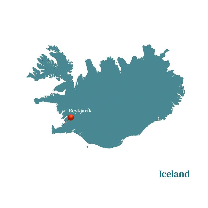
REGION
IcelandTHEME
TrekACTIVITIES
HikingDURATION
12 daysDIFFICULTY
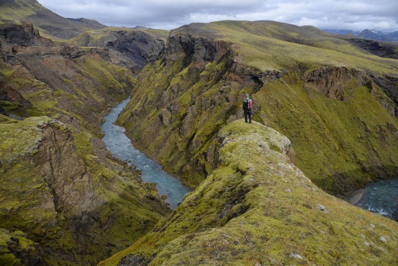
ModerateThis beautiful trekking tour without portage takes place in the heart of the most unusual and wild landscapes of the volcanic highlands of the Öraefi Sud, from the caldera of Torfajökull/Hrafntinnusker in the west to the mysterious lake Langisjór in the east, crossing the Eldgjá fault. The itinerary follows the most secret and spectacular passages of the volcanic rift. The pace of this great trek is quite brisk. Apart from carrying a light backpack, all equipment, provisions, and luggage are transported by a 4×4 support vehicle that follows the rare winding trails through the Highlands (Fjallabak South Trail). The small group size and our light equipment allow us to cover long distances while sometimes giving the impression of strolling.
Only a small part of this strange planet is known: the famous valley of Landmannalaugar, a bit too popular for our taste, will be just our starting point for an adventure where we will be far from everything for six days.
This grand trekking tour is specially designed for those who wish to fully immerse themselves in the wilderness and discover barely imaginable landscapes. It is part of our collection journeys and is aimed at purist hikers with an adventurous spirit. It takes place in the heart of the most unusual and wild landscapes of the volcanic highlands of the Öræfi Sud.
The itinerary follows the most secret and spectacular passages of the volcanic rift. The pace of this trek is quite brisk. Apart from carrying a light backpack, all equipment, provisions, and luggage are transported by a 4×4 support vehicle that follows the rare winding trails through the Highlands (Fjallabak South Trail).
Detailed program
DAY 1 | REYKJAVIK
Transfer by regular bus to downtown Reykjavik. Arrival at Hotel Klettur. Check-in to your standard room. Dinner on your own. Overnight stay.
DAY 2 | REYKJAVIK / HVANNGIL / MÆLIFELLSSANDUR
1.5 hours of driving – 1.5 hours on a track – approx. 5 hours of hiking – approx. 15 km – Altitude 550 m > 563 m
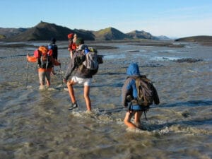
Meet your guide early in the morning at 7:30 AM at Reykjavik’s central bus station (BSI) in hiking gear, with your main travel bag packed and your backpack on your shoulder (don’t forget your hiking sandals for the first river crossing). Depart for a three-hour drive through the southern plains, then along the Fjallabak south track, which slowly climbs into the highlands through pastures and moss-covered lava fields. Here you can admire the alignment of mountain ranges, all perfectly parallel and aligned in the same direction: the direction of the Mid-Atlantic Ridge that crosses Iceland from north to south. In favorable weather, you can see three large ice caps: Mýrdalsjökull, Eyjafjallajökull, and Tíndafjallajökull. Arrive in Hvanngil early in the afternoon.
DAY 3 | CROSSING MÆLIFELLSSANDUR
Approx. 5 hours of hiking – approx. 15 km – Altitude 550 m > 563 m
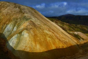
Exiting the Hvanngil hills, we suddenly emerge onto the strange flatness of the black sand Mælifellssandur, bordered by the imposing Myrdalsjökull ice cap. On the other side of the sand, we cross stands the perfect, solitary cone of Mælifell, covered in fluorescent moss, like a telluric Mont Saint Michel. To the east of this small desert, we reach the shelter of the hills at the foot of Torfajökull, where the beautiful and warm Strútur hut is located.
DAY 4 | HÓLMSÁRLÓN / STRÚTUR
Hiking for 6-8 hours – approx. 19 km – Altitude 563 m > 563 m
We progress along the shores of the long, narrow lake Hólmsárlón. At the “red bottoms” site, we reach the extraordinary turquoise lake Hólmsárlón and the waterfalls at the end of the lake that plunge into a red crater. Unforgettable bath at the end of the world in a hot spring.
DAY 5 | STRÚTUR / ALFTAVÖN
Hiking for 7-8 hours – approx. 22 km – Altitude 563 m > 444 m
Walking along the Eldgjá fissure, “fire gorge,” the largest eruptive fissure on the planet’s surface, now covered in moss and crossed by clear streams. During the six-year eruption (A.D. 934-940), lava gushed from several vents over a length of 75 km (47 miles). The lava from this fissure covered 781 square km (302 square miles) of the southern country. Fortunately, massive eruptions like those of Eldgjá and Laki are very rare; otherwise, life would likely not be possible on Earth. Although the hazards posed by lava flows and volcanic gases have significant impacts on humanity, they are still tiny compared to what our great blue planet is capable of. The gentle landscape of the “swan lake hook,” where we stop, almost makes you forget that this country is the result of repeated cataclysms.
DAY 6 | ALFTAVÖTN / HÓLASKJÓL
Hiking for 2-3 hours – approx. 8 km – Altitude 444 m > 329 m
Short hike along an old Eldgjá lava flow, covered in moss and traversed by a beautiful clear stream (which we will ford twice). We return to the Fjallabak North track, left seven days earlier, at the edge of the inhabited lands of the Skaftafellssýsla district, bordering the enormous petrified lava river of Laki, where the muddy Skaftá glacial river rushes and meanders.
DAY 7 | HÓLASKJÓL
Rest day to appreciate the beautiful landscape of Hólaskjól.
DAY 8 | HÓLASKJÓL / ÖXATINDAR
Hiking for 5-6 hours – approx. 16 km – Altitude 329 m > 450 m
Day along the Eldgjá fissure, “fire gorge,” the largest eruptive fissure on the planet’s surface. Despite all these superlatives, the tiny landscapes are comfortably at ease here, with springs, clear streams, and a small zen garden. We reach the powerful muddy waters of the Skaftá. On the other bank, the endless lavas of Laki, which is the largest lava flow in recorded history (1783-1785), spread out.
DAY 9 | SKAFTÁ / SVEINSTINDUR
Hiking for 6-7 hours – approx. 18 km – Altitude 450 m > 600 m
We reach Sveinstindur, the first cone of the jagged Fagrifjöll chain with black and green conical volcanoes. Easy ascent of Mount Sveinstindur from which you can admire a fabulous 360° panorama. To the south stretch the strange lava fields of Laki, covered in fluorescent green moss and partly flooded by the overflows of the Skaftá. To the north, the majestic and narrow turquoise lake Langisjór stretches for dozens of kilometers, bordered by the Fagrifjöll chain towards the massive ice of the immense Vatnajökull.
DAY 10 | LANGISJÓR AND THE FAGRIFJÖLL
Hiking for 7-8 hours – approx. 20 km – Altitude 600 m > 600 m
A full day along Langisjór at the foot and on the narrow Fagrifjöll chain. Their name means “beautiful mountains.” Given the sobriety of the Icelandic language, they must be to deserve such a name. We progress on the narrow green and black spine of Fagrifjöll, sometimes along the lake shore, sometimes on the easiest hills, admiring to the south the partly flooded lava expanses of Laki and the incredible jade green of the lake set in its black ash and fluorescent green moss case.
DAY 11 | GRÆNAFJALLSGARÐUR / LANDMANNALAUGAR / REYKJAVIK
Hiking for 2-3 hours – approx. 10 km – 240 km of track and road
We head west along a black and green rift valley bordered by imposing palagonite alignments of Grænnafjallsgarður and Gréttir to first reach the Fjallabak North track on foot, then with the help of our jeep. Either we return via the south coast or via Landmannalaugar, where we stop for a short walk of 2 or 3 hours. Late arrival in the capital around 8 PM. Currently, it is not possible to specify in advance which route will be chosen to return to Reykjavik. However, we will try to inform you before the trip if you need this information.
Arrival in Reykjavik. Free transfer to Hotel Klettur. Check-in to your standard room. Dinner on your own. Overnight stay.
DAY 12 | REYKJAVIK
Breakfast. Transfer by regular bus to Reykjavik international airport.
Enf of our service
Travel periods
Departures from 08/07/2026 to 16/08/2026Prices
Pricing information
OUR PRICE INCLUDES :
- Airport taxes of 144 euros (subject to change)
- Flybus transfers airport/hotel Reykjavik/airport
- 2 nights in a standard double room at Hotel Klettur Reykjavik with breakfast
- French and English-speaking guide
- Round-trip bus transfer to the mountains
- Transport of your luggage by 4×4 vehicle
- Accommodation in refuges and campsites
- Full board from lunch on Day 2 to breakfast on the last day of the trek
- Complimentary assistance insurance
OUR PRICE DOES NOT INCLUDE :
- Taxi or municipal bus fare from your accommodation to the meeting point on Day 2
- Taxi or bus fare from the drop-off point in Reykjavik to your accommodation upon return from the trek
- Paid showers in refuges
- Small group supplement if the group has fewer than 6 adult participants
- Currency exchange rate fluctuations
- Cancellation insurance
- Multirisk “PREMIUM” insurance (please inquire)
- International flights
Good to know
- Difficulty Level: 3-4 (Sustained)
- Average Daily Distance:** approx. 14-16 km
- Total Distance Covered:** approx. 142 km/10 days, 170 km/12 days
- Total Hiking Time:** approx. 55-68 hours
- Altitude Range:** 135 m to 800 m
- Total Ascent:** approx. 3660 m
- Total Descent:** approx. 3560 m
For detailed additional information, please download the PDF.
You will like also
The Besseggen hike starting from Oslo
The Besseggen is one of Norway’s most famous hikes, and this comprehensive 2-day trip from Oslo will offer you a fantastic experience in the stunning Jotunheimen National Park. Bessegen is a ...
the 28/06/2026 and 12/09/2026 From
455€
REGION
Norway
THEME
Hiking, Trek
ACTIVITIES
Cruise, Glacier, Hiking
DURATION
2 days
DIFFICULTY
DemandingDiscovering Jotunheimen: The Green Route from Oslo
This hike is designed for hikers with average physical condition and basic hiking and outdoor skills. The route takes you directly into the heart of Jotunheimen, through the beautiful Bygdin ...
the 24/06/2026 and 11/09/2026 From
1,780€
REGION
Norway
THEME
Adventure, Hiking, Trek
ACTIVITIES
Cruise, Hiking
DURATION
6 days
DIFFICULTY
ModerateDiscovery Hike of Jotunheimen: The Green Route, the Royal Route from Oslo
This hike combines our popular green route “Discovery of Jotunheimen” with two days of hiking along the Royal Route. It is designed for hikers with average fitness levels, possessing some basic ...
the 24/06/2026 and 11/09/2026 From
2,275€