RÉGION
IcelandTHÉMATIQUE
TrekACTIVITÉS
HikingDURÉE
10 daysNIVEAU
ModerateA beautiful 8-day supported and luggage-free trek circumnavigating the volcano Mount Hekla from south to north along its western flank, arriving in 4 days, from refuge to refuge, in the valley of Landmannalaugar, followed by crossing the Hrafntinnusker Caldera and its mysterious surroundings to finish at the foot of the Tindfjöll Massif.
Programme détaillé
DAY 1 | REYKJAVIK
Transfer by regular bus to the city center of Reykjavik. Arrival at Hotel Klettur. Check-in to your standard room. Dinner on your own. Overnight stay.
DAY 2 | REYKJAVIK / FARMS OF HEKLA
Drive 160 km – 3-4 hours walk – approx. 12 km – Altitude 135 m > 175 m
Meet your guide at 7:30 at the bus station in downtown Reykjavik in trekking attire, ready to go, with your daypack and your packed trekking bag. One piece of luggage can be kept in storage at your accommodation in Reykjavik. Departure for a 2-hour drive through the southern moors. Brief stop at our warehouse in the village of Hella where we load travel bags, provisions, and equipment onto the trailer of our support jeep. After an hour on the trail, we start the hike towards the tiny farms of Hekla, south of the volcano. These farms have had to move several times over the centuries, and the farmers do not always agree on remembering the exact location of the grandparents’ farm swallowed by a lava flow. Bucolic and dilapidated atmosphere, full of the charm of this strange countryside. Camp on the meadow. Despite the nearby volcano, the landscape here is green, and some ancient lava flows are covered with moss and clusters of Arctic birch barely larger and as old as “bonsai”, creating with clear springs gushing from the chaos of real Japanese gardens.
DAY 3 | WESTERN FLANK OF HEKLA
Hike for 7-8 hours – approx. 22 km – Altitude 135 m > 320 m
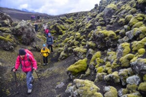
We cross the Ytri-Rangá, a clear spring river. Then we tackle the last alignment of palagonite hills that protect the last shreds of countryside from the scorched lands. On the other side, we arrive on the moon, at the very foot of the monster, and cross an expanse of scoria of perfect flatness. The surrounding black is so dark that it becomes blue like the plumage of a crow. Tiny, we progress in an entirely mineral world on the infinite scree plain that borders the eastern flank of the volcano, where most of the lava flows from the last eruptions were ejected.
DAY 4 | VALAGJÁ / MY LOÐMUNDUR
Hike for 5-6 hours – approx. 17 km – Altitude 320 m > 590 m
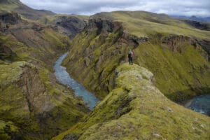
Some lava flows are less than six years old, some are beginning to be buried under black scoria, sometimes beige pumice, as Hekla also has acidic eruptions. Silvery lichens and green velvet mosses settle on the lava flows. As we move away from Hekla, the landscape softens, and the green of the tundra gradually wins over the stretches of black scoria that rain down on the country with each eruption. We reach the crown of Loðmundur, an old subglacial volcano reflecting in the beautiful lake of Loðmundarvatn. We have definitively left the volcanic system of Hekla.
DAY 5 | HIKE TO LANDMANNALAUGAR
Hike for 6-7 hours – approx. 16 km – Altitude 590 m > 700 m
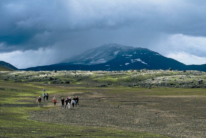
The trail leads us through extraordinary landscapes. First, we go around the beautiful lake shining at the foot of Mt Loðmundur. We should be able to admire a pair of Common Loons up close, then we climb the north flank of the Hrafntinnusker Caldera and enter the pastel colors of acidic volcanism, from blue to pink through all possible ochres. Extraordinary viewpoint over the caldera and the valley of Landmannalaugar. We begin the descent towards the refuge and the camping site in the valley, somewhat surprised to suddenly encounter so many people, so many tents, and so many vehicles after 4 days of wonderful solitude. After a bath (optional) in the famous hot water river, we return by jeep along the track to find the tranquility of Landmannahellir.
Périodes de voyage
Départs du 04/07/2026 au 07/09/2026Tarifs
Informations sur les prix
OUR PRICE INCLUDES :
- Airport taxes €144 at this time, subject to change
- Flybus transfers airport/hotel Reykjavik/airport
- 2 nights in standard double room at Hotel Klettur Reykjavik with breakfast
- French and English-speaking guide
- Round-trip bus transfer to the mountains
- Transportation of your luggage by 4×4 vehicle
- 7 nights in mountain refuges
- Full board from lunch on Day 2 to breakfast on the last day of the trek
- Complimentary assistance insurance
OUR PRICE DOES NOT INCLUDE :
- Taxi or municipal bus fare from your accommodation to the meeting point on Day 2
- Taxi or bus fare from Reykjavik drop-off point to your accommodation upon return from the trek
- Paid showers in the refuges
- Small group supplement if the group is less than 6 adult participants
- Currency exchange rate fluctuations
- Cancellation insurance
- Premium Multi-risk insurance (please contact us for details)
- International flights
Bon à savoir
- Difficulty level: 3-4 challenging
- Average daily distance: approx. 14-16 km
- Total distance covered: approx. 142 km
- Total walking time: approx. 55 hours
- Altitude between: 135 m and 800 m
- Cumulative positive elevation: approx. 3660 m
- Cumulative negative elevation: approx. 3560 m
Vous aimerez aussi
Randonnée du Bessegen au départ d’Oslo
Bessegen est l’une des randonnées les plus célèbres de Norvège, et ce voyage complet de 2 jours au départ d’Oslo vous offrira une expérience formidable dans le magnifique parc national ...
le 28/06/2026 et le 12/09/2026 À partir
de 455€
RÉGION
Norvège
THÉMATIQUE
Randonnée, Trek
ACTIVITÉS
Croisière, Glacier, Randonnée
DURÉE
2 jours
NIVEAU
ExigeantRandonnée découverte du Jotunheimen : la route verte au départ d’Oslo
Cette randonnée est conçue pour les randonneurs de condition physique moyenne, avec quelques compétences de base en randonnée et en plein air. Cet itinéraire vous emmène directement au cœur de ...
le 24/06/2026 et le 11/08/2026 À partir
de 1,780€
RÉGION
Norvège
THÉMATIQUE
Aventure, Randonnée, Trek
ACTIVITÉS
Croisière, Randonnée
DURÉE
6 jours
NIVEAU
ModéréRandonnée découverte du Jotunheimen : la route verte, la route Royale au départ d’Oslo
Cette randonnée combine notre populaire route verte Découverte du Jotunheimen avec deux jours de randonnée le long de la route Royale. Elle est conçue pour les randonneurs de condition physique moyenne, ...
le 24/06/2026 et le 11/09/2026 À partir
de 2,275€