RÉGION
IcelandTHÉMATIQUE
TrekACTIVITÉS
HikingDURÉE
12 daysNIVEAU
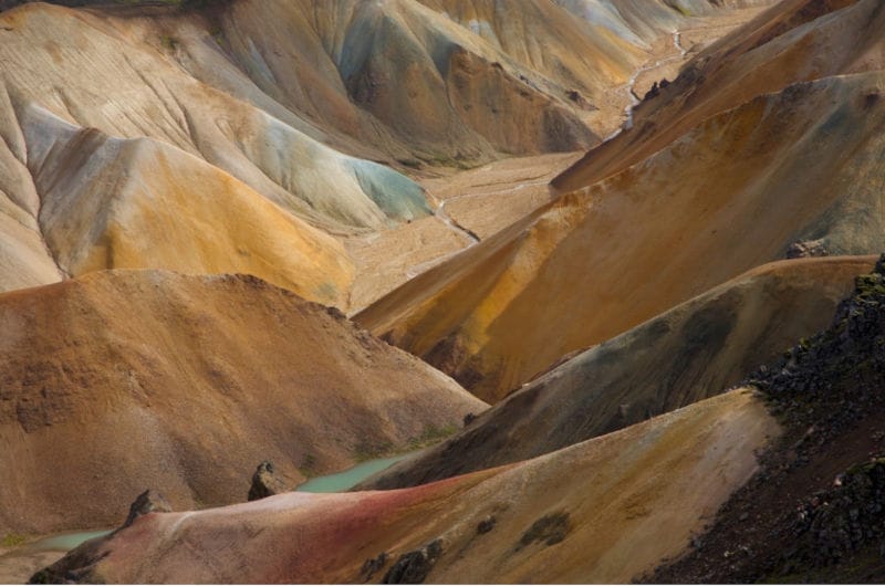
ModerateThis beautiful and adventurous trek takes place in the heart of the most unusual and wild volcanic highlands of the Öraefi Sud, between the Mt Hekla volcano to the west and the Eldgjá fault to the east, crossing the caldera of Torfajökull/Hrafntinnusker.
The itinerary follows the most secret and spectacular passages of the volcanic rift. The pace of this grand trek is fairly brisk. Except for carrying a light backpack, all equipment, provisions, and luggage are transported by a 4×4 assistance vehicle that navigates the rare, winding tracks through the Highlands (Fjallabak South Route).
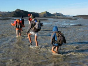
The small group size and lightweight gear allow for covering long distances while sometimes feeling like a leisurely stroll. While camping in these high latitudes is very enjoyable in good weather, it can become an “unforgettable” experience during a serious storm. Therefore, we have opted to include some nights in refuges when they are on our path. These small refuges and restored old sheepfolds, which hikers bless in bad weather, were nonexistent or in ruins a few years ago. They have been beautifully restored and are always located in magical places. The isolation of these territories requires everyone to be in good physical condition and to actively participate in daily tasks such as setting up camp and assisting the guide with meal preparation.
This beautiful trek is specially designed for those who wish to fully immerse themselves in the wild nature and discover barely imaginable landscapes.
Privatize this Trek !
This trek, as described here, can be privatized for your family, hiking club, university, company, or clients if you are a mountain guide.
- Choose one of our available scheduled dates
- Or select any other date if availability permits
Programme détaillé
DAY 1 | REYKJAVIK
Transfer by regular bus to downtown Reykjavik. Arrival at Hotel Klettur. Check-in to your standard room. Dinner on your own. Overnight stay.
DAY 2 | REYKJAVIK / HEKLA FARMS
Road 160 km – Hike 3-4 h – approx. 12 km – Altitude 135 m > 175 m
Meet your guide at 7:30 am at the bus station in downtown Reykjavik dressed in trekking attire, ready to go, with your daypack and your packed trekking bag. One luggage can be stored at your accommodation in Reykjavik. Departure for a 2-hour drive through the southern moorlands. Brief stop at our warehouse in the village of Hella where we load travel bags, supplies, and equipment into our assistance jeep’s trailer. After an hour of off-road driving, we start the hike towards the tiny farms of Hekla south of the volcano. These farms have had to move many times over the centuries, and farmers do not always agree on remembering the exact location of the grandparents’ farm swallowed by a lava flow. Bucolic and dilapidated atmosphere, full of the charm of this strange countryside. Camping in the meadow. Despite the nearby volcano, the landscape here is lush green, and some ancient lava flows are covered with moss and clusters of arctic birch barely taller and as old as bonsai, creating with clear springs that gush from the chaos real Japanese gardens.
DAY 3 | WEST FLANK OF HEKLA
Hike 7-8 h – approx. 22 km – Altitude 135 m > 320 m
We cross the Ytri-Rangá, a clear spring river. Then we tackle the last alignment of palagonite hills that protect the last shreds of countryside from the scorched lands. On the other side, we reach the moon, at the very foot of the monster, and cross a stretch of perfectly flat scree. The surrounding black is so dark that it turns blue like the plumage of a raven. Tiny, we progress in an entirely mineral world on the endless scree plain that borders the eastern flank of the volcano, where most of the recent eruptions have spewed out.
DAY 4 | VALAGJÁ / MY LODMUNDUR
Hike 5-6 h – approx. 17 km – Altitude 320 m > 590 m
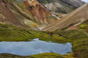
Some lava flows are less than six years old, some begin to be buried under black scree, sometimes beige pumice, as Hekla also has acidic eruptions. Silver lichens and velvety green mosses settle on the lava flows. Moving away from Hekla, the landscape softens, and the green of the tundra gradually wins over the expanses of black scree that rain down on the country with each eruption. We reach the crown of Loðmundur, an old sub-glacial volcano reflected in the beautiful lake of Loðmundarvatn. We have definitively left the volcanic system of Hekla.
DAY 5 | HIKE TO LANDMANNALAUGAR
Hike 6-7 h – approx. 16 km – Altitude 590 m > 700 m
The trail leads us through extraordinary landscapes. First, we bypass the beautiful lake shining at the foot of Mt Loðmundur. We should be able to admire up close a couple of Great Northern Divers (Common Loon) then we climb up the northern flank of the Hrafntinnusker Caldera and enter the pastel colors of acidic volcanism, from blue to pink passing through all possible ochres. Extraordinary viewpoint over the caldera and the Landmannalaugar valley. We begin the descent towards the valley’s refuge and camping area, somewhat surprised to suddenly encounter so many people, so many tents, and so many vehicles after 4 days of wonderful solitude. After a (optional) bath in the overly famous hot river, we return by jeep along the trail to regain the tranquility of Landmannahellir.
DAY 6 | EXPLORATION OF THE HRAFNTINNUSKER REGION
+/- 5-7 hours of walking
The metaphor “black raven reefs” for Hrafntinnusker is a beautiful example of Icelandic’s ancient and natural metaphorical poetry. It means the reefs or shallows (Sker) of obsidian (Hrafntinna) (Hrafn for raven and Tinna for intense black): black vitrified lava with sometimes blue or green reflections, sharp as a razor blade which spreads here on the soft pastel rolling hills of acidic rocks of the caldera crown of the same name. We will cautiously see the countless solfataras with boiling mud pools, powerful and noisy steam vents. On the edge of the caldera, we advance on a flatness of black scree that leads towards Mount Hekla, which dominates the nearby horizon with its imposing and legendary mass. We also explore a fairy-tale landscape of small volcanic cones and streams of pure water in a closed valley at the foot of the imposing monolith of light rock of Laufafell.
DAY 7 | LJÓSÁRTUNGUR TO HVANNGÍL
Hike 7-8 h – approx. 21 km – Altitude 785 m > 550 m
Descending towards Fjallabak South, we can admire here the alignment of mountain ranges, all perfectly parallel and aligned in the same direction: the direction of the mid-Atlantic ridge that crosses Iceland from North to South. In favorable weather, there is a spectacular view of three large glaciers: Mýrdalsjökull, Eyjafjallajökull, and Tíndafjallajökull. Following the course of the Markarfljót canyon, we descend south through hills and wet meadows, crossing clear streams.
DAY 8 | MÆLIFELLSSANDUR
Hike 5-6 h – approx. 15 km – Altitude 550 m > 563 m
Through the Mælifellssandur desert, where the huge glacier cap of Mýrdalsjökull gently slopes down. In the middle of this strange black flatness stands the solitary cone of Mælifell covered in fluorescent moss (made famous by Yann Arthus Bertrand’s aerial photos). The comfortable Strútur refuge is located in the strange landscape that lies between the southern flank of the Torfajökull caldera and the Mýrdalsjökull glacier cap.
DAY 9 | HÓLMSǺRLÓN TO STRÚTUR
Hike 6-8 h – approx. 19 km – Altitude 563 m > 563 m
Progression along the shores of the long and narrow Hólmsárlón lake. At the place called “the red bottoms”, we reach the extraordinary turquoise lake of Hólmsárlón and the waterfalls at the end of the lake that plunge into a red crater. Unforgettable bath at the end of the world in a hot spring.
DAY 10 | STRÚTUR TO ALFTAVÖTN
Hiking for 7-8 hours – approx. 22 km – Altitude 563 m > 444 m
Walk along the Eldgjá Rift, “Fire Gorge,” the largest eruptive fissure on the surface of the planet, now covered by moss and crossed by clear streams. During the six years of activity of this eruption (A.D. 934-940), lava erupted from several vents over a length of 75 km (47 miles). The lava from this fissure covered the southern part of the country with 781 square kilometers (302 square miles). Fortunately, huge eruptions like Eldgjá and Laki are very rare; otherwise, life would probably not be possible on Earth. Although the risks posed by lava flows and volcanic gases have significant repercussions for humanity, they are still minuscule compared to what our great blue planet is capable of. The gentle landscape of the “swan lakes hook,” where we make a stopover, almost makes us forget that this country is the result of repeated cataclysms.
DAY 11 | GRÆNAFJALLSGARðUR / LANDMANNALAUGAR / REYKJAVIK
Hiking for 2 hours – approx. 8 km – Altitude 444 m > 329 m – Route 250 km
A short hike along an ancient lava flow of Eldgjá, covered in moss and where a beautiful torrent of clear water plays and leaps (which will need to be crossed twice). At Hólaskjól, where our hike ends, we reconnect with the Fjallabak Nord trail, left seven days earlier. We are on the outskirts of the inhabited lands of the district of Skaftafellssýsla, on the edge of the enormous petrified lava river of Laki, where the powerful glacial, silty river Skaftá rushes and wanders from Vatnajökull.
Return to Reykjavik and civilization:
From Hólaskjól, we return to Reykjavik (Central bus station – BSI) 1) either with two of our vehicles along the South Coast, via Vík, with an arrival around 5 p.m. 2) or by regular 4×4 bus via Landmannalaugar. Late arrival in the capital around 7 p.m., possibly later if you decide to make a stopover for a few hours at Landmannalaugar.
Currently, we are unable to specify in advance which route will be chosen to return to Reykjavik. However, we will try to provide you with an answer before the trip if you need this information.
Arrival in Reykjavik. Free transfer to Hotel Kletttur. Check-in to your standard room. Dinner on your own. Overnight stay.
DAY 12 | REYKJAVIK
Breakfast. Transfer by regular bus to Reykjavik International Airport.
End of our services
Périodes de voyage
Départs du 04/07/2026 au 12/08/2026Tarifs
Informations sur les prix
OUR PRICE INCLUDES :
- Airport taxes of 144 euros at present, subject to change
- Flybus transfers airport/hotel Reykjavik/airport
- 2 nights in standard double room at Hotel Klettur Reykjavik including breakfast
- French and English-speaking guide
- Assistant driver for the guide
- Round trip bus transfer to the mountains
- Transportation of your luggage by 4×4 vehicle
- 9 nights in mountain huts
- 1 or 2 nights camping
- Full board from lunch on Day 2 to breakfast on the last day of the trek
- Complimentary assistance insurance
OUR PRICE DOES NOT INCLUDE :
- Accommodation and meals in Reykjavik
- Taxi or municipal bus fare from your accommodation to the meeting point on Day 2
- Taxi or bus fare from the drop-off point in Reykjavik to your accommodation upon return from the trek
- Paid showers in the mountain huts
- Small group supplement if the group is fewer than 6 adult participants
- Exchange rate fluctuations
- Cancellation insurance
Premium comprehensive insurance (please inquire) - International flights
Bon à savoir
- Difficulty level: 3-4 moderate to challenging
- Average daily distance: approx. 14-16 km Total distance covered: approx. 142 km
- Total walking time: approx. 55 hours
- Altitude range: between 135 m and 800 m
- Cumulative positive elevation gain: approx. 3660 m
- Cumulative negative elevation loss: approx. 3560 m
Vous aimerez aussi
Randonnée du Bessegen au départ d’Oslo
Bessegen est l’une des randonnées les plus célèbres de Norvège, et ce voyage complet de 2 jours au départ d’Oslo vous offrira une expérience formidable dans le magnifique parc national ...
le 28/06/2026 et le 12/09/2026 À partir
de 455€
RÉGION
Norvège
THÉMATIQUE
Randonnée, Trek
ACTIVITÉS
Croisière, Glacier, Randonnée
DURÉE
2 jours
NIVEAU
ExigeantRandonnée découverte du Jotunheimen : la route verte au départ d’Oslo
Cette randonnée est conçue pour les randonneurs de condition physique moyenne, avec quelques compétences de base en randonnée et en plein air. Cet itinéraire vous emmène directement au cœur de ...
le 24/06/2026 et le 11/08/2026 À partir
de 1,780€
RÉGION
Norvège
THÉMATIQUE
Aventure, Randonnée, Trek
ACTIVITÉS
Croisière, Randonnée
DURÉE
6 jours
NIVEAU
ModéréRandonnée découverte du Jotunheimen : la route verte, la route Royale au départ d’Oslo
Cette randonnée combine notre populaire route verte Découverte du Jotunheimen avec deux jours de randonnée le long de la route Royale. Elle est conçue pour les randonneurs de condition physique moyenne, ...
le 24/06/2026 et le 11/09/2026 À partir
de 2,275€